
Memorial’s Dr. John Jamieson spent some of the warm summer months on a cold-water cruise — Arctic cold.
The professor of earth sciences joined a multidisciplinary research team aboard the research vessel R/V G.O. Sars, led by chief scientist Dr. Rolf Pederson, director of the K.G. Jebsen Centre for Deep Sea Research at the University of Bergen, Norway.
The researchers used the Aegir remotely operated vehicle (ROV) to dive along a submarine volcanic ridge searching for black smoker vents.
Black smokers
Black smokers are hot water springs that form on underwater volcanoes.
Smokers are known for their unique habitats, which are home to organisms that don’t depend on sunlight for sustenance. They also contain valuable minerals and researchers are trying to understand the vents as a system – how the rock, biology and fluids interact with each other – an important component of determining the environmental impacts of mining them.

1/ Tied up at the dock
The Norwegian research vessel G.O. Sars, tied up at the dock in Tromsø, Norway, prior to the start of the cruise. The G.O. Sars is jointly owned by the University of Bergen and the Institute for Marine Research.

2/ Vent samples
Scientists from the K.G. Jebsen Centre for Deep Sea Research measuring pH, dissolved H2S and other geochemical parameters from hydrothermal vent fluids collected at the seafloor using the Aegir remotely operated vehicle.

3/ Longyearbyen
The G.O. Sars tied up at the port of Longyearbyen, the world's northern-most town, on the island of Svalbard, during a brief stopover to pick up some equipment and crew.

4/ Deep depths
Preparing a gravity corer to deploy to the ocean floor 2,800 meters below. The corer is lowered to the seafloor using a steel cable controlled from a winch on the ship, and then allowed to drop and core into the seafloor sediment. The corer is then hoisted back to the ship, where the sedimentary layers are stored and brought back to shore to analyze the changing chemistry and types of microorganisms that live in deep marine sediments.

5/ Ocean bottom seismometer
Deploying an ocean bottom seismometer (OBS). An OBS can detect very faint seismic activity and is used to study submarine tectonic and volcanic processes, such as faulting, magma displacements and hydraulic fracturing within oceanic crust.

6/ Constant monitoring
Dr. Jamieson working in the science control room. Ship operations continue 24 hours a day for the entire four-week cruise. Because the team was working well above the Arctic Circle in summer months, the sun never set for the entire cruise.

7/ Mapping the seafloor
The Hugin autonomous underwater vehicle (AUV) was deployed several times for seafloor mapping missions. The AUV is programmed on deck, and then dives down several kilometres to near the seafloor, where it flies a survey pattern to map the topography of the seafloor. Geochemical and magnetic sensors on the AUV are also used to detect traces of black smoker hydrothermal vents, metal-rich hot springs on the seafloor.

8/ Black smoker rock
A rock sample taken from black smoker chimney at the Loki's Castle vent field. This vent field was discovered on a previous cruise. The team returned to the area to collect rock, fluid and biological samples from the vent field.

9/ Post dive
Dr. Jamieson and a colleague collected samples out of the sampling tray of the ROV Aegir after a successful dive.
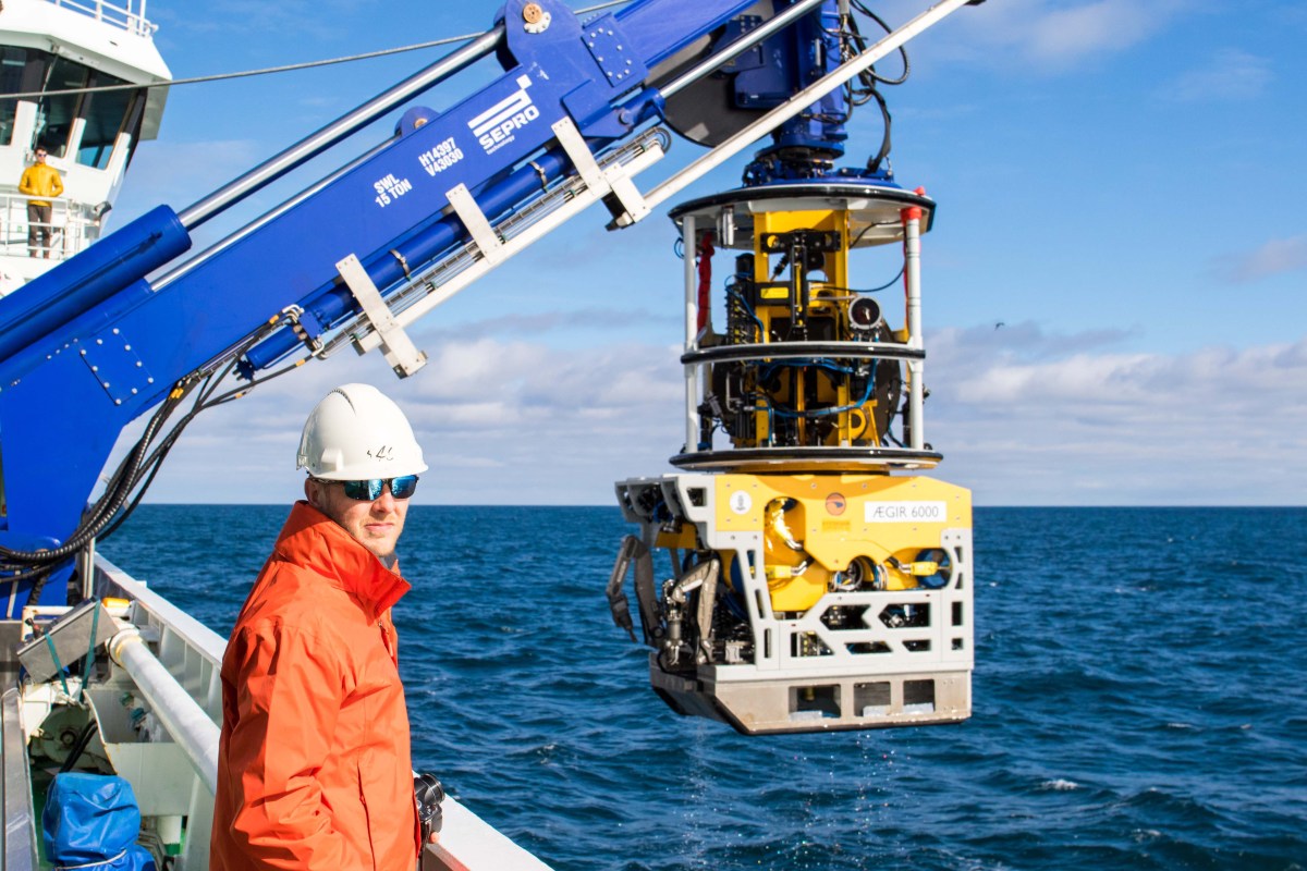
10/ Aegir ROV
Dr. Jamieson on board the G.O. Sars, with the Aegir remotely operated vehicle in the background. It was being recovered after a 12-hour dive to the seafloor 2.8 kilometres below.
The vessel left Tromsø, Norway, and, after a brief stop in Longyearbyen, Svalbard, went back out to sea to an area west of Svalbard, between Norway and Greenland.
Watch the video below for footage acquired by the research team on their expedition.
Research activities included collecting rock and biological samples with the ROV, collecting sediment cores, mapping the seafloor with the Norwegian Hugin autonomous underwater vehicle and deploying ocean bottom seismometers, which can detect earthquake and submarine volcanic processes.
Funding for the project was provided by the K.G. Jebsen Centre.


